Flusshinweise
Isère: Stade National de Canoë Kayak, Bourg Saint Maurice
IV 0.87 km direct

Isère @ Landry 35.1 m³/s @ 03:30
10 | 25 | 50 m³/s (Indirect calibration!)
Resultate 1 - 7 von 7
Befahrbarkeit
https://pegelalarm.at/paw/chart.html?commonid=W0040002-fr
This gauge gives an immediate level for the slalom section.... The actual gauge at moutier has a 3h time delay ????
This gauge gives an immediate level for the slalom section.... The actual gauge at moutier has a 3h time delay ????
Gefahr aufgehoben
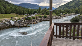
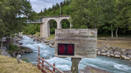
die Gefahr von #3515 besteht nicht mehr. Anscheinend wurde die Slalomstrecke nach dem grossen Murgang von 2019 wieder hergerichtet, es sind jedenfalls nur noch noch ein paar Kiesansammlungen sichtbar (siehe Fotos).
BE CAREFUL : Mud flow on the river. Many rapids must have changed. The best is to ask locals before running this section.
ATTENTION : Coulée de boue sur la rivière. Des changements sont attendus dans les prochains jours. Demandez aux locaux pour connaître l'état de la rivière.
http://www.eauxvives.org/forum/viewtopic.php?p=322020#p322020
https://www.facebook.com/watch/?v=465693837585199
ATTENTION : Coulée de boue sur la rivière. Des changements sont attendus dans les prochains jours. Demandez aux locaux pour connaître l'état de la rivière.
http://www.eauxvives.org/forum/viewtopic.php?p=322020#p322020
https://www.facebook.com/watch/?v=465693837585199
Info
Bewertung NW-MW-HW
Pegel http://www.rdbrmc.com/hydroreel2/station.php?codestation=246
NW = 5 m3/s
MW = 25 m3/s
HW = 50 m3/s
NW = 5 m3/s
MW = 25 m3/s
HW = 50 m3/s
nach oben


