Home
The Map
List View


 Flusshinweise
Befahrbarkeit
English Summary
Karte Einbetten
Systemstatus
Kontakt und Team
Datenlieferanten
Overview
Download
Rivermap Japan
The Map
List View
Befahrbarkeit
English Summary
Karte Einbetten
Systemstatus
Kontakt und Team
Datenlieferanten
Overview
Download
Rivermap Japan
![]() "Rivermap Supporter" Group
"Rivermap Supporter" Group
Flusshinweise
Als Grundlage dient wenn immer möglich der Flussführer.
Seite: 1 2 3 4 5 . . . 222 223 224
Resultate 1 - 20 von 4468
Glenner (CH), Uors - Peiden
Gefahr aufgehoben
Baum rausgesägt.
Auch einer direkt nach der Crux in der rechten Durchfahrt, war bei 8m3 gerade an der Oberfläche.
Auch einer direkt nach der Crux in der rechten Durchfahrt, war bei 8m3 gerade an der Oberfläche.
Fium Orbo (FR), Haut (Cavo - Parc accrobranche)
Divers
Gefahren mit 34cm. Alles unter 40cm ist wenig Wasser. Bei uns war es eigentlich super. Jedoch sehr steinig am Anfang. Aufpassen in eine stelle nach dem Schlucht. Dort gibt's eine Siphon, und mit sehr wenig Wasser ist noch relativ aggressiv.
Arkadventures.ch
Arkadventures.ch
Travo (FR), Haut (Pont de Chisa - Pont de Ghjineparu)
Info
Am Montag gefahren mit 80cm.
Geht schon und die Wasserfälle sind immernoch traumhaft.
Arkadventures.ch
Geht schon und die Wasserfälle sind immernoch traumhaft.
Arkadventures.ch
Golo (FR), Très haut (Maison forestière de Poppaghia - Passerelle)
Befahrbarkeit
Heute mit nur CA 80cm , nicht ideale Voraussetzungen.
Es geht aber extrem steinig. Es hat noch Schnee dort oben. Sobald es wärmer wird hat es bestimmt wieder eine gute Wasserstand.
Arkadventures.ch
Es geht aber extrem steinig. Es hat noch Schnee dort oben. Sobald es wärmer wird hat es bestimmt wieder eine gute Wasserstand.
Arkadventures.ch
Vorderrhein (CH), Ilanz - Versam
Hinweis zu Meldung 5840: betrifft den linken Flussarm vor der Hängebrücke, wo im Moment viel Wasser runterläuft.
Sorne (CH), Courfaivre - Delémont
Befahrbarkeit
Bei 10 m³/s ist zwischen Courvaivre und Campingplatz/Fussballfelder von Delémont alles fahrbar.
Unter der Strassenbrücke in Courtételle könnte sich bei höheren Wasserständen ein Rücklauf bilden.
Unter der Strassenbrücke in Courtételle könnte sich bei höheren Wasserständen ein Rücklauf bilden.
Sorne (CH), Courfaivre - Delémont
Bewertung NW-MW-HW
Befahrung bei 10 m³/s, ein idealer Wasserstand (würden wir als MW vorschlagen). Unter 9m*/s ist eine Fahrt nicht zulässig (siehe Hinweis vom 4.2.2024).
Vorderrhein (CH), Ilanz - Versam
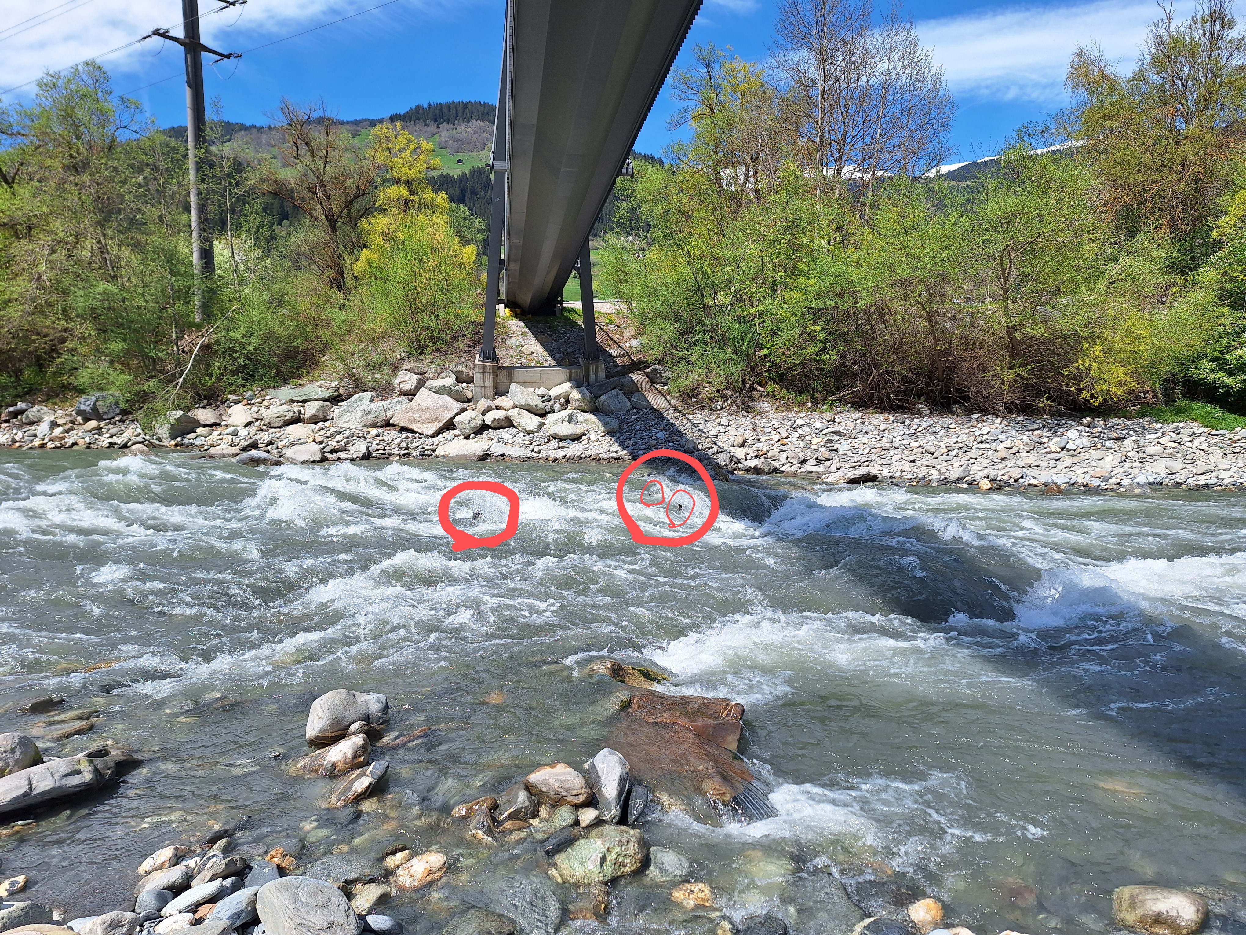
Unter der Hängebrücke vor dem alten Kieswerk: zur Zeit fließt ein Großteil des Wassers links. Direkt unter der Hängebrücke hat es links im Fluss mehrere Eisen. Für versierte Paddler*innen kein Problem, für andere gefährlich!
Bachelard (FR), Les Longs - Le grand pont D902
Fahrverbot
Section servant de frontière au parc national du Mercantour interdite à la navigation par un ancien Arrêté préfectoral

Landquart (CH), Küblis - Schiers
Befahrbarkeit
Befahren bei 25m3 am 21.4.2024. Bäume beim Erdrutsch versperren immer noch die Durchfahrt. Kehrwasser links zum Umtragen sind klein, in der Anfahrt hat es eine kleine Walze.
Baum von #5504 immer noch drin, aber gut links umfahrbar. es hat noch weitere Bäume, die vom Ufer hineinragen, aber alle umfahrbar sind. Generell mehr Holz im Bach. Es wurde nach Fideris für eine längere Strecke das linke Ufer komplett abgeholzt.
Baum von #5504 immer noch drin, aber gut links umfahrbar. es hat noch weitere Bäume, die vom Ufer hineinragen, aber alle umfahrbar sind. Generell mehr Holz im Bach. Es wurde nach Fideris für eine längere Strecke das linke Ufer komplett abgeholzt.
Areuse (CH), Mitte Schlucht - Boudry
Flash!
Path will be closed for 6 weeks starting from 5 mai 2024. Could be a problem to scout the gorge or could get eyes on you.
https://www.rts.ch/info/regions/neuchatel/2024/article/les-gorges-de-l-areuse-fermees-durant-six-semaines-28477392.html
https://www.rts.ch/info/regions/neuchatel/2024/article/les-gorges-de-l-areuse-fermees-durant-six-semaines-28477392.html
Areuse (CH), Mitte Schlucht - Boudry
Bewertung NW-MW-HW
Confirming #5000, please adjust, thanks
Guil (FR), Combes de Château Queyras et de l'Ange gardien (Château Queyras - La Triple Chûte)
Flash!
50m après le pont de Chateau Queyras, vérifier si cet arbre est toujours là
Rißbach (AT), Standard (Hinterriß - Klamm)
Befahrbarkeit
derzeit 2 Bäume quer über den Fluss. Der erste etwa 1000m und der zweite etwa 200m vor dem Straßen-S. Beide gut sichtbar. Mit einer kleinen Säge könnte man die Durchfahrt beim 2. Baum leicht freisägen (ein paar Äste entfernen).
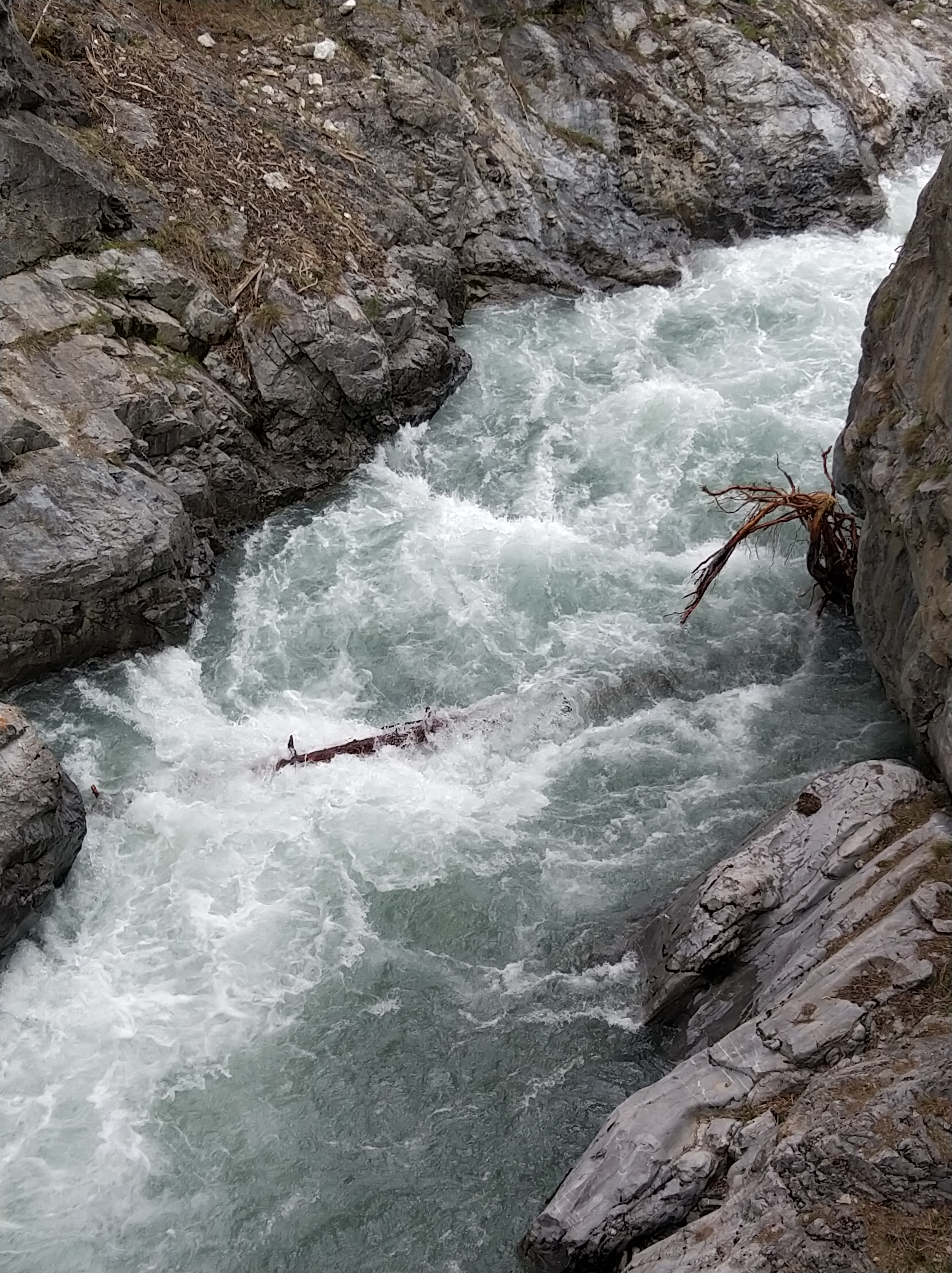
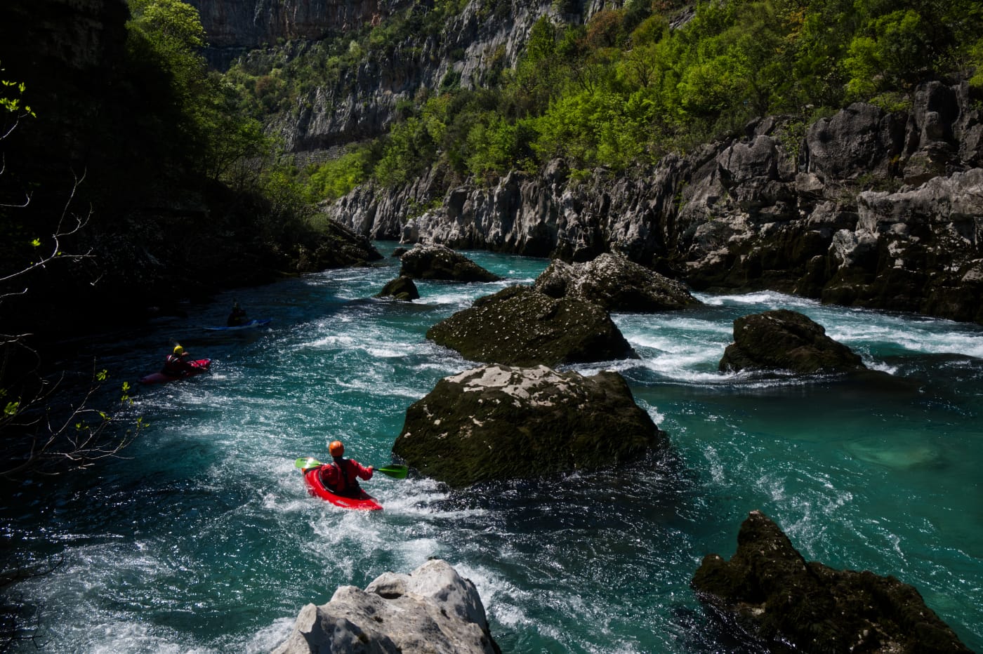
Morača (ME), Kanjon
Info
I paddled this section on April 13-th 2024 at a level of 75 cm. We put in at 42.703611,19.376722 at the confluence with the Sievernica river, where there is an easy access to the road above. The section is mostly WW 2 with some class 3 rapids. However the rapid in the Platjie canyon at 42.674361,19.369028 is class 4-5 depending on water levels. It is boxed in between vertical walls and cannot be portaged. Scout from the road above and from the big rocks at the entry to the rapid. The line is from the middle left to the right over the first drop into the eddy river right. Scout again from the rocks if necessary. From there, stay center dropping over the rock in the middle and then choose either left or right. We took out at 42.586528,19.358833 , where the road is easily accessible.
Morača (ME), Middle
Bewertung NW-MW-HW
Minimal level should probably be at 70cm
Cem (AL), Lower
Info
I paddled this section on April 10-th 2024 at 80cm. Many good and clean WW 3 rapids. The first four are the most difficult and might even be WW 4. I definitely recommend scouting them. Further down there are some sections with conglomerate rocks with undercuts and siphons. Keep your distance.
We used the put-in and take-out as given here. They worked well and are convenient to access from the road. Don't cross the boarder into Montenegro on the river. There is boarder police watching the river and they have no sense of humor.
We used the put-in and take-out as given here. They worked well and are convenient to access from the road. Don't cross the boarder into Montenegro on the river. There is boarder police watching the river and they have no sense of humor.
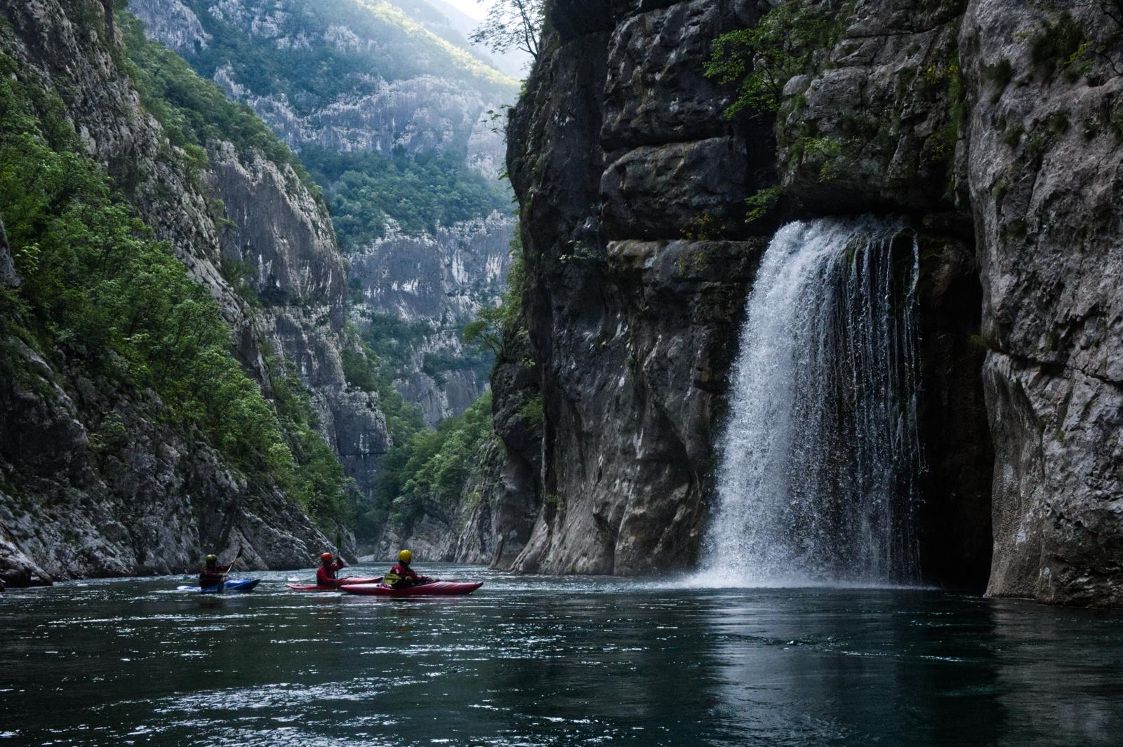
Morača (ME), Middle
Info
I paddled this section on April 9-th 2024 at a level of 80cm. A lot of good and clean WW3, maybe some bordering at 4 at higher levels. We put in a bit higher up at 42.773972, 19.391833, which adds a beautiful extra section passing below the monastery and its waterfall pouring in from an overhanging rock to the right. The put-in required walking through some grassland below the transformer station at the road and finding a path that leads down to the river. We took out river right at 42.703611,19.376722 at the confluence with the Sievernica river, where there is an easy access to the road above. Don't miss this exit because the river goes into the canyon section afterwards without further exits.
The section leads mostly through a dense forest, so watch out for wood in the river. Otherwise the section has far less undercuts and siphons than the lower Moraca.
The section leads mostly through a dense forest, so watch out for wood in the river. Otherwise the section has far less undercuts and siphons than the lower Moraca.

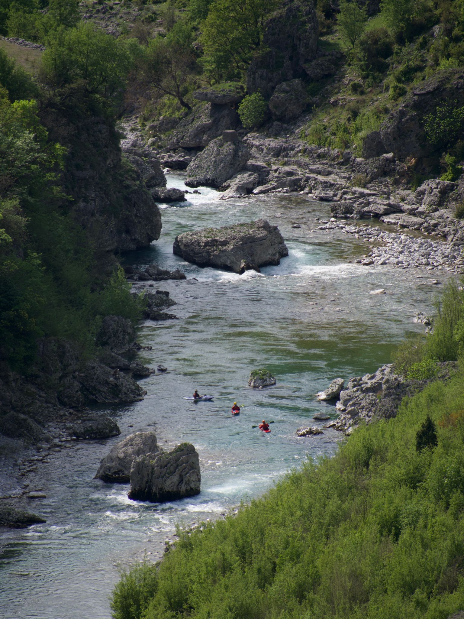
Morača (ME), Lower
Info
I paddled this section on April 7th 2024 at a level of 85cm. We put in a bit lower down, at 42.559333,19.340722, where there is a good access to the river from the road and took out a bit earlier at Autocamp Titograd.
At this level the section is mostly WW 2 with some 3. The rock is mostly conglomerate hence there are many big undercuts and siphons. The passages are wide enough to stay clear of them.
At this level the section is mostly WW 2 with some 3. The rock is mostly conglomerate hence there are many big undercuts and siphons. The passages are wide enough to stay clear of them.
Ribo (CH), Oberer (Steg - Vergeletto)
WATCH OUT!!! A Tree is in the last drop of the little Vergletto Canyon. You can watch it easy river right.
Seite: 1 2 3 4 5 . . . 222 223 224
nach oben