Home
The Map
List View


 Flusshinweise
Befahrbarkeit
English Summary
Karte Einbetten
Systemstatus
Kontakt und Team
Datenlieferanten
Overview
Download
Rivermap Japan
The Map
List View
Befahrbarkeit
English Summary
Karte Einbetten
Systemstatus
Kontakt und Team
Datenlieferanten
Overview
Download
Rivermap Japan
![]() "Rivermap Supporter" Group
"Rivermap Supporter" Group
Flusshinweise
Loue: La source de la Loue - Mouthier (usine électrique)
IV-V (VI) 3.45 km direct

Loue [source] @ Ouhans 2.7 m³/s @ 13:00
7 | 11 | 14 m³/s (Indirect calibration!)
Resultate 1 - 13 von 13
Befahrbarkeit
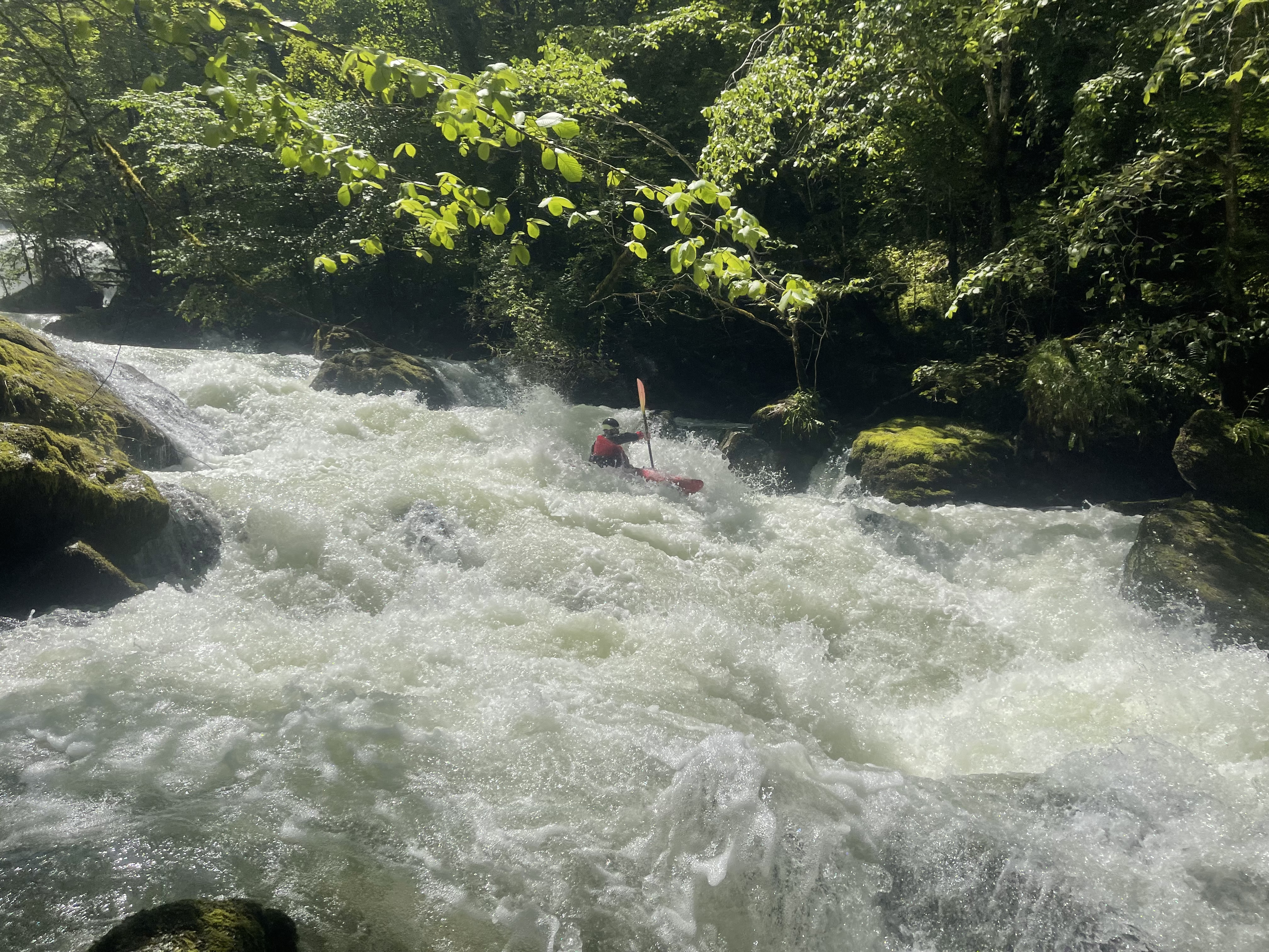
Nur ein Baum im hohen Wasserfall, alles andere holzfrei.
Befahrbarkeit
Le niveau de la source ne donne que de niveau de la source.les znciend se réfère au niveau de vuillafans 55 m3 pour avoir environ 5 dans le parcours
Info
In 2024 there will be work on the Haute Loue dam so there should be occasions in September for some exceptional runs.
Log in the waterfall, also one in the start of the long slide, and many that you can avoid. 97m3 @Vuillafans, 7,3 @source.


Info
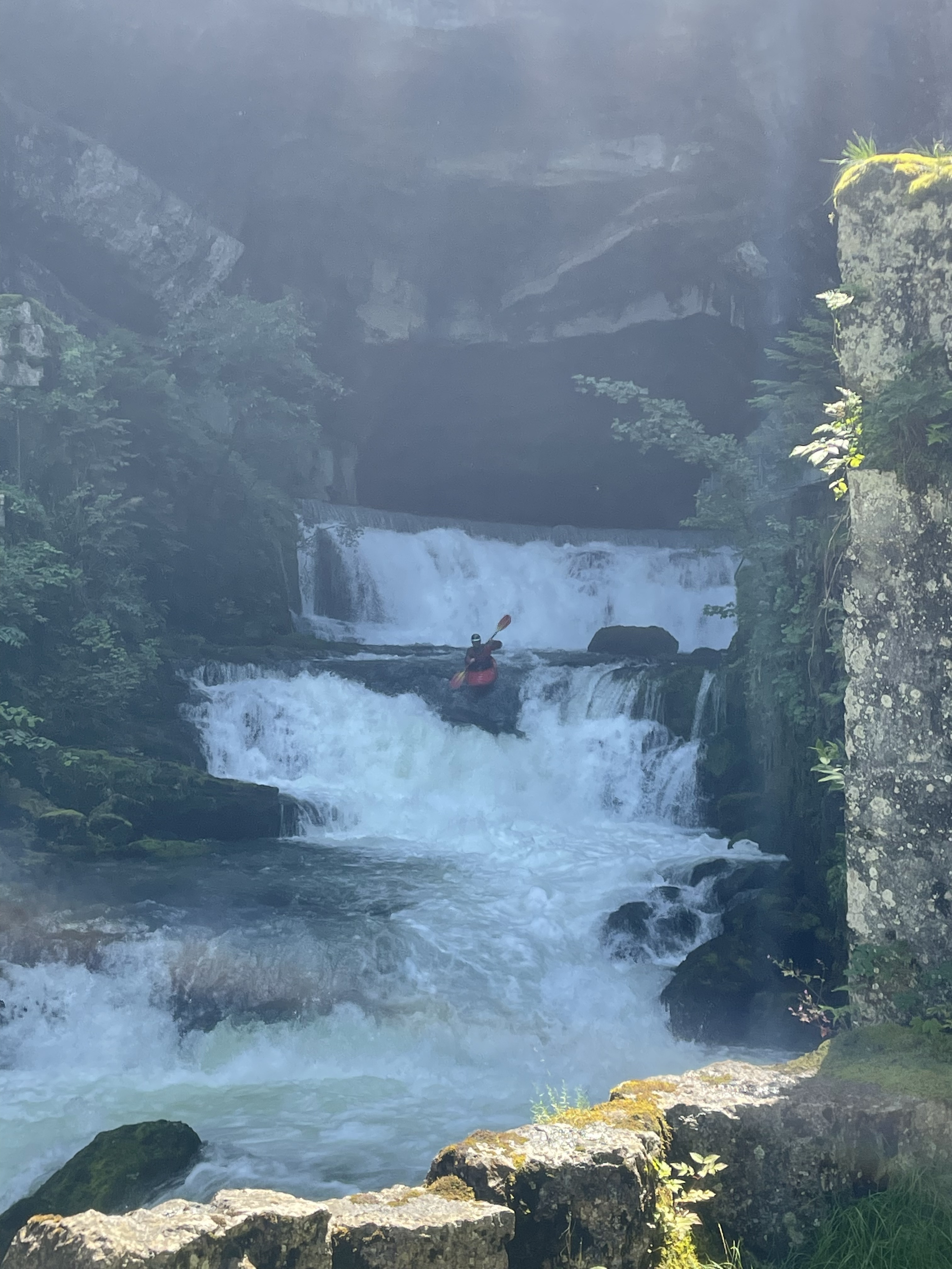
We had 7.1 at the Source. It was good for initial drops out of the cave. Below the dam things got interesting with a much higher flow than expected, certainly not ‘low’ as 7.1 suggests. At these flows (whatever they were?) things start to edge towards a fairly solid Class V experience.
Reading the post from 2018, it seems that the gauge might not represent the true level in the gorge; it might be worth walking the little path down past the dam to see how things look.
There is a large log wedged vertically in the left (runnable) side of the big falls and other wood (new?) littered throughout.
Bewertung NW-MW-HW
gauge doesn't work
Befahrbarkeit | 8.2 m³/s | 4.3.2017
we had 8.2m3/s (dropping) on the La Source gauge and 45m3/s on the Vuillafans. No water was spilling over the dam :-( and residual water seemed even less than 8m3. It was very low and we decided not to run it.
Power plant seemed fully working. There was plenty of water at the take out.
Power plant seemed fully working. There was plenty of water at the take out.
, still good to go")

Befahrbarkeit
It sounds that the Loue dam is opening its gates again.
When it is the case, the level can be lower than expected.
For example, some paddlers did it at 7m3/s and it was really low and some French people did it at 12m3/s afterwards and it was lower than usual.
We are suspecting the power plant to run 100% again.
When it is the case, the level can be lower than expected.
For example, some paddlers did it at 7m3/s and it was really low and some French people did it at 12m3/s afterwards and it was lower than usual.
We are suspecting the power plant to run 100% again.
Befahrbarkeit | 12.7 m³/s | 12.11.2016
Run on 12.11.2016, at 12.7m3/s (power station on). High but manageable.
Tree in a flat section in the middle, easy bypass on the left.
Bunch of trees in the right channel of the drop a bit before the long slide. Left is clear but there is a river wide tree (submerged at this flow) right after it.
We cut out 2 trees that were blocking a short slide on the left (before last bigger drop). Tree still stuck but parallel with the current now. There is a sneak line to the right around rocks.
A tree in the second to last slide before the power-station (100m above). Otherwise we cleaned everything.
The powerstation is working normally now (18m3/s), 7 - 11 - 14 looks correct
The powerstation is working normally now (18m3/s), 7 - 11 - 14 looks correct
Befahrbarkeit | 67 m³/s | 16.2.2014
gefahren am 16.2.2014 bei 68-65m3/s = mittel bis hoch. Ist WWV bei diesem Pegel. Baum kurz nach dem 10m-Fall haben wir rausgesägt, sonst keine Fahrt versperrende Bäume.
Wenige und kleine (2-3 Boote gross) Kehrwasser in der Anfahrt vor dem 10m-Fall. Danach sind die Kehrwasser zahlreicher.
Es hat einen Wanderweg am linken Ufer der ganzen Strecke entlang ca 10-20 Höhenmeter über dem Fluss. Alles ist umtragbar.
Wenige und kleine (2-3 Boote gross) Kehrwasser in der Anfahrt vor dem 10m-Fall. Danach sind die Kehrwasser zahlreicher.
Es hat einen Wanderweg am linken Ufer der ganzen Strecke entlang ca 10-20 Höhenmeter über dem Fluss. Alles ist umtragbar.


Bewertung NW-MW-HW
Hilfspegel: http://www.rdbrmc.com/hydroreel2/station.php?codestation=22
NW = 50 m3/s
MW = 60 m3/s
HW = 70 m3/s
NW = 50 m3/s
MW = 60 m3/s
HW = 70 m3/s
nach oben