Home
The Map
List View


 Flusshinweise
Befahrbarkeit
English Summary
Karte Einbetten
Systemstatus
Kontakt und Team
Datenlieferanten
Overview
Download
Rivermap Japan
The Map
List View
Befahrbarkeit
English Summary
Karte Einbetten
Systemstatus
Kontakt und Team
Datenlieferanten
Overview
Download
Rivermap Japan
![]() "Rivermap Supporter" Group
"Rivermap Supporter" Group
Flusshinweise
Doubs: Refrain (Barrage - Usine Électrique)
IV (IV+) 2.51 km direct

Doubs @ En aval de Barrage du Refrain [estimé] 10.37 m³/s @ 00:40
10 | 25 | 80 m³/s (Indirect calibration!)
Seite: 1 2
Resultate 1 - 20 von 25
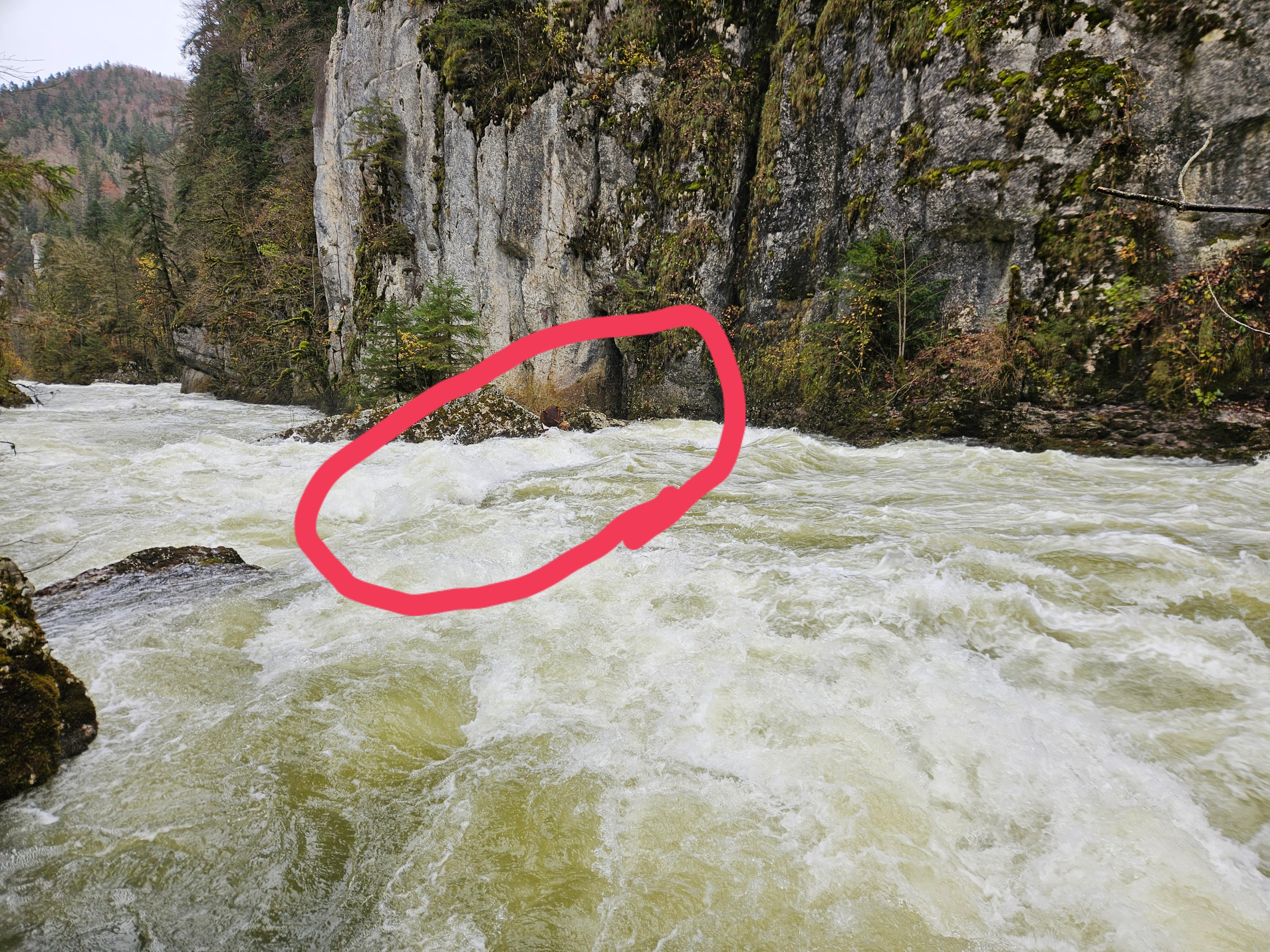
Holz in der ersten größeren Stelle
Wood in the first main Rapid
Pegel: ca. 100 Kubik
Wood in the first main Rapid
Pegel: ca. 100 Kubik
Befahrbarkeit
Kraftwerk scheint momentan in Revision. Es laufen z.Zt. ca 20m3 mehr über die Wehrkrone
Divers
Snief hatte bisschen carnage und hab mein paddel verloren...falls es jemand am ufer stecken sieht, schwarz, marke Hardcore, mit pogies dran...bin durxh den stausee gepaddelt und hab es nicht gefunden..
Bäume im letzten Rapid vor dem E-Werk, können ganz links umfahren werden. Sind von der Strasse aus einsehbar.
Gefahr aufgehoben
Gefahren 01/10.
Baum gemäss #4688 liegt nicht mehr da.
Baum gemäss #4688 liegt nicht mehr da.
Baum in der letzen, schwierigen Stelle (kurz bevor die Strasse wieder parallel zum Fluss verläuft: Der Stamm liegt rechts im Bach, liess sich bei 39m3 links- und rechtsseitig umfahren.

Info
Winterliches Wildwasser. Per Mitte Januar 2021 keine Bäume im Bach, alles frei.
https://vimeo.com/504073487
https://vimeo.com/504073487
Bewertung NW-MW-HW
This graph is useful for thinking about what is happening to water levels.
https://riverzone.eu/station/compare/70019673-62cd-364c-96ee-0d45cf0d72c8.Q@976273cc-99bd-5e34-981c-796087563088.Q@3e33b032-1d49-55db-a095-0773085137ef.Q@31eecd8c-441b-34af-ba13-745416fd849f.Q
There is no gauge directly on the section.
La Rasse gauge is above the reservoir above the barrage (and the powerstation in-take) above the section.
Le Noirmont is currently the closest station below the section (and the powerstation out-fall).
Goumois is further downstream.
Info
The rapids in the bottom third of the section are easier but still fun. These can be used for a quick warm-up, or for short training laps, if the upper rapids are judged too difficult or consequential.
Bewertung NW-MW-HW
35 cumecs estimated. Nice class IV level.
Bewertung NW-MW-HW
Apparently there is an agreement that the Châtelot hydro station should only reduce flow at a maximum rate 2 cumecs/hr for ecological reasons.
Here is an interesting article, from before the regulation, describing the effects of sudden flow reduction. https://www.letemps.ch/barrage-maltraite-doubs
Here is an interesting article, from before the regulation, describing the effects of sudden flow reduction. https://www.letemps.ch/barrage-maltraite-doubs
Bewertung NW-MW-HW
La jauge BAFU "Combe des Sarrasins" vient d’être retirée.
Il y a une autre jauge BAFU en aval "Le Noirmont, La Goule"
http://www.hydrodaten.admin.ch/de/2370.html
La calibration pour cette jauge est BE=40, ME=55
Le calcul synthétique Rivermap sera ajusté.
-----------------------------
Die BAFU-Station "Combe des Sarrasins" ist außer Betrieb.
Unterhalb, die BAFU-Station „Le Noirmont, La Goule“ funktioniert noch.
Die Kalibrierung für „Le Noirmont, La Goule“ ist NW = 40, MW = 55.
Http://www.hydrodaten.admin.ch/de/2370.html
Die Rivermap-Syntheseberechnung wird bald angepasst werden.
----------------------------
The BAFU gauge "Combe des Sarrasins" has been discontinued.
There is a downstream BAFU gauge "Le Noirmont, La Goule"
http://www.hydrodaten.admin.ch/de/2370.html
The calibration for this gauge is LW=40, MW=55.
The Rivermap synthetic calculation will be adjusted.
Befahrbarkeit | 58 m³/s | 4.3.2017
am 4.3.2017 3x gefahren bei 58m3/s. Es hatte deutlich mehr Wasser als auf den Bildern von Eintrag 1825, obwohl dieser auch 58m3/s angibt. Ich nehme an, das Kraftwerk hat bei uns gerade weniger produziert.
Alles gut fahrbar und spassig. Es kann noch gut mehr vertragen. Bei 80-100m3 dürfte es ein guter Wuchwasserklassiker werden :-)
Alles gut fahrbar und spassig. Es kann noch gut mehr vertragen. Bei 80-100m3 dürfte es ein guter Wuchwasserklassiker werden :-)

Bewertung NW-MW-HW
The order of things:
1. out-fall from le Châtelot hydro station
2. The RDBRMC river gauge "La Rasse": http://www.rdbrmc.com/hydroreel2/station.php?codestation=604
3. Lac de Biaufond. The water for the Refrain hydro-station is taken from here.
4. The ww section.
5. Out-fall from the Refrain hydro-station
6. The BAFU river gauge "Combe des Sarrasins":
http://www.hydrodaten.admin.ch/de/2270.html
This link gives information on the Refrain hydro configuration:
http://massif-du-jura.developpement-edf.com/images/edf-1r1t-massif-jura-plaquette_doubs.pdf
- 23 cumecs max
- all the water is drawn from the lake
- 3 turbines
To estimate the actual flow on the section, take the Combe des Sarrasins gauge reading judge and subtract a judgement of the powerstation out-flow (visible at the take out). YMMV.
Bewertung NW-MW-HW | 40 m³/s | 15.05.2016
Paddled with 40 m³/s on the BAFU Combe des Sarrasins gauge, dropping to 35 m³/s.
Nice quality class IV.
Nice quality class IV.
Seite: 1 2
nach oben